
Stay informed about critical FAA helicopter route updates affecting IAD and BWI airports. Learn about permanent changes, safety improvements, and implementation timelines for aviation operators.
The Federal Aviation Administration has published significant updates to helicopter route charts as part of its regular 52-day update cycle. These changes include permanent modifications to helicopter zones at Washington Dulles International Airport (IAD) and Baltimore/Washington International Thurgood Marshall Airport (BWI), following safety recommendations after the January midair collision at Ronald Reagan Washington National Airport (DCA).
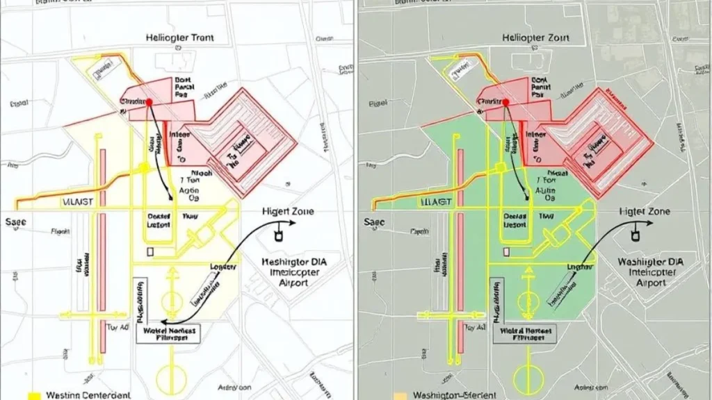
Before and after comparison of helicopter zone boundaries at IAD
Background & Context: FAA’s Role in Helicopter Route Management
The FAA’s management of helicopter routes in the National Capital Region has taken on increased significance following the January 29 midair collision at Ronald Reagan Washington National Airport. This incident, which involved an Army Sikorsky UH-60 Black Hawk and a commercial aircraft, prompted immediate safety measures and a comprehensive review of helicopter operations in congested airspace.
The FAA’s authority to regulate airspace and establish helicopter routes stems from its mandate to ensure the safe and efficient use of navigable airspace. In high-traffic areas like the Baltimore-Washington metropolitan region, this responsibility includes:
- Designating specific helicopter routes and zones
- Establishing altitude restrictions and separation standards
- Implementing communication protocols between helicopters and air traffic control
- Coordinating with military, law enforcement, and medical operators
- Publishing and maintaining current aeronautical charts
The current updates represent a significant step in the FAA’s ongoing efforts to enhance safety in the National Capital Region’s complex airspace, which accommodates commercial airlines, general aviation, military operations, and essential helicopter services.
Key Changes to Helicopter Routes and Zones
| Location | Extended to within 2.5 miles of the approach path | Updated Configuration | Safety Impact |
| IAD Zone 3 | Reduced boundary, moved 1.5 miles further from the approach path | Overlapped with the departure corridor | Increased lateral separation from commercial traffic |
| IAD Zone 4 | Reduced the potential for head-on helicopter encounters | Reduced size, relocated east of departure corridor | Eliminated potential conflict with departing aircraft |
| BWI North Transition | Single altitude corridor (1,500 ft) | Stratified altitude assignments based on direction | Reduced potential for head-on helicopter encounters |
| Broad Creek Transition | Not previously established | New transition route south of DCA | Greater vertical separation from approach traffic |
Stakeholders & Affected Parties
The FAA’s helicopter route updates impact a diverse group of aviation stakeholders operating in the Baltimore-Washington metropolitan area. Understanding these stakeholders is crucial for the effective implementation of the new procedures.
Helicopter Operators

Medical helicopter operations are among the affected stakeholders.
- Medical evacuation services
- Law enforcement agencies
- Military units
- News-gathering organizations
- Private charter operators
Helicopter Operators

ATC personnel implementing new route procedures
- Tower controllers at IAD and BWI
- TRACON approach controllers
- Air Route Traffic Control Centers
- Flight Service Stations
- Airspace managersacuation services
Helicopter Operators
Medical helicopter operations are among the affected stakeholders.
- Residents under flight paths
- Local government officials
- Community action groups
- Environmental organizations
- Airport community liaison offices
The FAA conducted stakeholder engagement meetings with the Department of Defense, metropolitan police departments, and medical helicopter operators to gather input before finalizing these changes. Congressional representatives and community groups were also consulted during the development process.
Implementation Challenges & Risk Mitigation
The implementation of updated helicopter routes and zones presents several operational challenges that the FAA and stakeholders must address to ensure safety and compliance.
Implementation Challenges
- Pilot training and familiarization with new routes
- Updating onboard navigation systems and databases
- Coordinating transition periods between old and new procedures
- Ensuring consistent communication between ATC and operators
- Managing operations during adverse weather conditions
Risk Mitigation Strategies
- Early distribution of digital charts (20 days before the effective date)
- Comprehensive controller training at affected facilities
- Stakeholder briefings and simulation exercises
- Enhanced monitoring during the initial implementation phase
- Established procedures for handling non-compliance
The FAA has emphasized that pilots must ensure they are using current and accurate aeronautical data for safety and compliance. The digital copies of updated charts were made available approximately 20 days before the effective date to allow sufficient time for familiarization.
“The agency continues to assess safety data and areas of risk in the Baltimore-Washington area, as well as other cities that have airports with high volumes of mixed traffic.”
Federal Aviation Administration Statement
Solutions & Best Practices for Operators
To facilitate the smooth adoption of the updated helicopter routes and zones, the FAA has provided guidance for operators and pilots. These best practices help ensure safety while minimizing operational disruptions.

Helicopter pilot reviewing updated route information.
Pre-Flight Planning
- Verify chart currency using the effective date (June 12, 2025)
- Review all notes and special instructions on helicopter charts.
- Identify changed boundaries for Zones 3 and 4 at IAD.
- Familiarize yourself with the new Broad Creek Transition route.
- Check NOTAMS for temporary restrictions or modifications
In-Flight Procedures
- Maintain strict adherence to published altitudes
- Ensure ADS-B Out is operational for position broadcasting.
- Establish early communication with the approach control.
- Request clarification if uncertain about route assignment.s
- Report any operational difficulties with new procedures.
Important Reminder: The FAA requires all aircraft operating around DCA to broadcast their position and identification using ADS-B Out, with minimal exceptions. This requirement extends to operations at IAD and BWI under the updated procedures.
Future Outlook & NextGen Integration
The helicopter route updates at IAD and BWI represent part of the FAA’s broader strategy to enhance airspace safety and efficiency. These changes align with several NextGen initiatives aimed at modernizing the National Airspace System.

NextGen technology integration with helicopter route management
How will these changes integrate with broader NextGen initiatives?
The updated helicopter routes incorporate NextGen principles through enhanced ADS-B requirements, data-driven airspace design, and improved vertical and lateral separation standards. Future iterations will likely include Performance-Based Navigation (PBN) procedures specifically designed for helicopter operations.
Will similar updates be implemented at other major airports?
Yes, the FAA has indicated it is scrutinizing aircraft traffic flows around other airports with complex mixed operations, including Burbank and Van Nuys in California. The lessons learned from the IAD and BWI implementations will inform these future updates.
Conclusion: Prioritizing Safety in Complex Airspace
The FAA’s updates to helicopter routes and zones at IAD and BWI represent significant steps toward enhancing safety in the National Capital Region’s complex airspace. These changes, implemented as part of the regular 52-day update cycle, incorporate lessons learned from the January midair collision at DCA while addressing specific operational needs at neighboring airports.
Key takeaways from these updates include:
- Integration with broader NextGen airspace modernization initiatives
- Reduced helicopter zone boundaries to increase separation from commercial traffic
- New transition routes are designed to enhance vertical separation.
- Mandatory ADS-B Out requirements for improved situational awareness

Helicopter operating under updated route procedures near IAD
As these changes take effect, continued collaboration between the FAA, operators, and local communities will be essential to ensure that helicopter operations remain safe, efficient, and responsive to the needs of all airspace users.
Also Read: FAA Final AD ATR: Hydraulic Pump & MEL Compliance in 2025